Transformative Environmental Monitoring to
Boost Observations in Africa
' stroke='white'%3e%3cpolyline id='img-bottom-arrow' points='148.484375 220.898438 157.802734 232.695312 166 220.898438'/%3e%3c/g%3e%3c/g%3e%3c/svg%3e)
Our ambition is to close the environmental in situ data gap in Africa. To fulfill this ambition our general objective is to have cost-effective innovative sensor networks that can be financed by the climate services we develop using these sensors. First, we build on recent sensor technology to make measurements cost-efficient. Then, applications are developed that generate large socio-economic value in the fields of geo-hazards, water management, and agricultural information
The three service clusters started with the rapid development of focus services. These services allow concrete business development by giving customers tangible actionable information
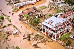
Flood Early Warning Systems
Volcanic eruptions (Virungas) are uncommon in Africa, but water-related geo-hazards such as mudslides, droughts, coastal erosion, subsidence, dust storms, tropical cyclones, and floods are particularly common. Sensors placed in TEMBO Africa sites will aid in reducing geohazard effects, particularly through longer-term monitoring and the creation of early warning systems.
Reservoir Management
Water management is a rather broad area, running from irrigation and drainage to flood control. We focus first on reservoir management as willingness and ability to pay are large.
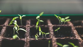
Agricultural information
The single greatest industry in terms of employment in Africa is agriculture. Despite the increased urbanization, 667 million people, or 59% of the world's population, still reside in rural areas, and this figure is rising. Africa is home to more than 60% of the world's uncultivated arable land, and there is no other continent where the difference between actual and potential production is as high. We can encourage farmers to grow more if they are insured. This service is about germination insurance.
In summary, TEMBO Africa :
Reuse as much as possible existing software platforms, avoiding inefficient use of resources, making use of the advantages of what is there (robust data flows in AgroApps platform; controlled data access and visualisation in TWIGA platform, etc.)
Use data standards from the Open Geospatial Consortium, to ensure easy data exchange with GEOSS and Copernicus
Use standard APIs and formats to develop scalable and modular Lego®-like elements for all services.


TAHMO
KMD
RainBow
TUD

HCP International

Ghana Insurance Association (GIA)
MicroStep-MIS
University for Development Studies
Geomatic Research & Developments SRL (GReD)
AGRO-APPS
SEBA Hydrometrie GmbH&Co.KG

University of Zambia

This project has received funding from the European Horizon Europe Programme (2021-2027) under grant agreement n° 101086209 (TEMBO Africa).
The opinions expressed on the website are of the authors only and in no way reflect the European Commission’s opinions. The European Union is not liable for any use that may be made of the information.
Copyright © TEMBO Africa . All Rights Reserved